Elevation Grids
Leapfrog Geo imports and exports elevation grids in common formats.
Importing an Elevation Grid
Elevation grid formats Leapfrog Geo supports include:
- Arc/Info ASCII Grid Files (*.asc, *.txt)
- Arc/Info Binary Grid Files (*.adf)
- Digital Elevation Model Files (*.dem)
- Surfer ASCII or Binary Grid Files (*.grd)
- SRTM Files (*.hgt)
- ESRI.hdr Labelled Image Files (*.img, *.bil)
- GeoTIFF Image Files (*.tiff, *.tif)
There are two ways to import an elevation grid:
- Import the grid to the Meshes folder. Right-click on the Meshes folder and select Import Elevation Grid.
- Import the grid as part of creating a topography. Right-click on the Topographies folder and select New Topography > Import Elevation Grid.
Navigate to the folder that contains the elevation grid file and open the file. The Import Elevation Grid window will be displayed:
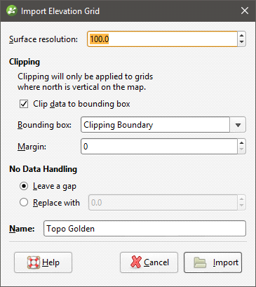
Leapfrog Geo automatically sets a Surface resolution based on the information in the file, but you can change the value if you wish. A lower value will produce more detail, but calculations will take longer. See Surface Resolution in Leapfrog Geo for more information.
When importing an elevation grid, note that the resolution cannot be changed once the file has been imported.
Data is automatically clipped to the clipping boundary, but you can change how the data is filtered to suit any bounding box that exists in the project. If you do not wish to clip the data, untick Clip data to bounding box.
The Margin value determines how far outside the selected Bounding box the elevation grid will extend.
The No Data Handling option determines whether NoData values are displayed as gaps or at a fixed elevation setting.
Click Import. If you are creating a new topography, you will then be prompted to enter a name for it and click OK.
The elevation grid will be added to the Meshes folder. If you imported the grid as part of creating a topography, a hyperlink to the grid in the Meshes folder will appear as part of the defined topography.
Exporting an Elevation Grid
For any mesh in a project, you can export an elevation grid for use in other software. Formats Leapfrog Geo can export are:
- ARC/Info ASCII Grid (*.asc)
- ESRI.hdr Labelled (*.bil)
- ENVI Raster Image (*.img)
- Surfer ASCII Grid (*.grd)
If you have the Maptek Link module, you can also export an elevation grid in VULCAN v7 .00g format. Contact Customer Support as described in Getting Support for more information about licensing this module.
To export an elevation grid, right-click on the mesh and select Export Elevation Grid. The Export Grid window will appear:
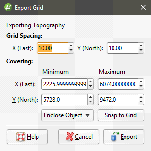
The Snap to Grid option changes the extents of the exported grid so that they coincide with the elevation grid spacing.
Enter the information required, then click Export to enter a filename and choose a location and format for the file.
Got a question? Visit the My Leapfrog forums at https://forum.leapfrog3d.com/c/open-forum or technical support at http://www.leapfrog3d.com/contact/support