Drillhole Desurveying Options
Drillhole desurveying computes the geometry of a drillhole in three-dimensional space based on the data contained in the survey table. Under ideal conditions, the drillhole path follows the original dip and azimuth established at the top of the drillhole. Usually, though, the path deflects away from the original direction as a result of layering in the rock, variation in the hardness of the layers and the angle of the drill bit relative to those layers. The drill bit will be able to penetrate softer layers more easily than harder layers, resulting in a preferential direction of drill bit deviation.
There are a number of paths a drillhole could take through available survey measurements, but the physical constraints imposed by drilling are more likely to produce smoother paths. Selecting the desurveying method that gives the best likely approximation of the actual path of the drillhole will ensure that subsequent modelling is as accurate as possible.
Leapfrog Geo implements three algorithms for desurveying drillholes:
These options are described in more detail below.
Another factor that affects how drillholes are desurveyed is how dip values are handled. When the survey table is imported, Leapfrog Geo sets the Negative survey dip points down value according to the data in the imported table. When the majority of the dip data in the table is positive, Leapfrog Geo assumes all these drillholes will point down and leaves the field Negative survey dip points down disabled. When most of the values are negative, the field is enabled. This field can be changed by double-clicking on the survey table to open it and then clicking on Compatibility to show the table’s desurveying settings:
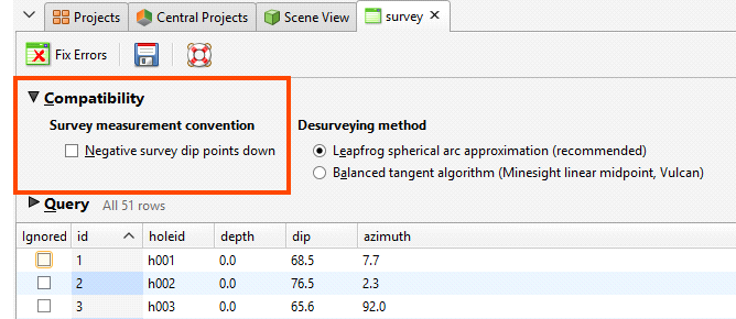
If you are going to change the automatically set value of Negative survey dip points down, consider carefully the implications if there is a mix of drillholes pointing down and up.
The other Compatibility setting relates to the algorithm used in desurveying the drillholes.
The Spherical Arc Approximation Algorithm
The default algorithm used in Leapfrog Geo is spherical arc approximation, which is sometimes referred to as the minimum curvature algorithm. Downhole distances are desurveyed exactly as distances along a circular arc:
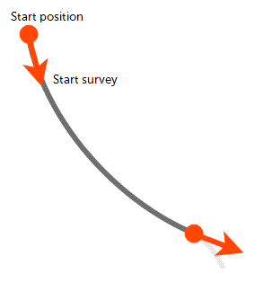
The algorithm matches the survey at the starting and end positions exactly and the curvature is constant between these two measurements. At the survey points, the direction remains continuous and, therefore, there are no unrealistic sharp changes in direction.
If you wish to use spherical arc approximation, there is no need to change any settings.
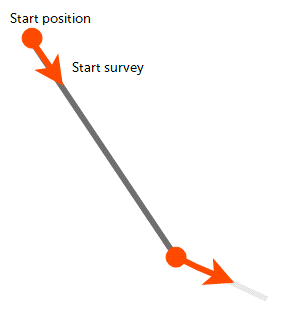
The Balanced Tangent Algorithm
The balanced tangent algorithm uses straight lines but attempts to improve the accuracy of the raw tangent algorithm by assigning equal weights to the starting and end survey measurements:
It is an improvement on the raw tangent algorithm but still suffers from an unrealistic discontinuity in the drillhole path. It is, however, a better approximation of the overall drillhole path and is reasonably accurate when the spacing between measurements is small.
To use the balanced tangent algorithm, double-click on the survey table in the project tree. Click on Compatibility and change the Desurveying method.
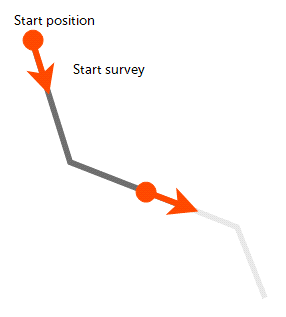
The Raw Tangent Algorithm
The raw tangent algorithm assumes the drillhole maintains the direction given by the last survey measurement until the next new measurement is reached:
This implies that the drillhole makes sharp jumps in direction whenever a measurement is taken, which is unlikely, except when the drillhole is being used to define a trench.
Collar tables have a trench column that indicates whether or not the drillhole is from a trench. When the trench column is ticked for a drillhole, the trench will be desurveyed using the raw tangent algorithm. Double-click on the collar table in the project tree, then tick the trench box for the drillholes you wish to desurvey using the raw tangent algorithm.
Got a question? Visit the Seequent forums or Seequent support